
Search Term Record
Metadata
Name |
Wayne Grove Forest Preserve |
Number of Archive records |
0 |
Number of Library records |
0 |
Number of Object records |
3 |
Number of Photo records |
0 |
Related Records
-
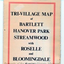
2016.1.19 - Map
Map, 32" x 21" unfolded, 10 1/2" x 5" folded, paper, white, printed in black and red, "Tri-Village Map of Bartlett, Hanover Park, Streamwood with Roselle and Bloomingdale ..." two-sided, Side A- Bartlett, Hanover Park, Wayne, Streamwood, Schaumburg, Hoffman Estates, Elgin, Side B- Bloomingdale, Roselle, Medinah, Hanover Park, Schaumburg and Glendale Heights. Created in 1971, by Bartlett cartographer John Isard, the map illustrates the communit...
Record Type: Object
-
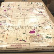
2021.23.1 - Map
Map, 43" w x 62" l, canvas, attached to wooden window shade roller on top, attached to black metal bar at bottom, Front- printed in black, "Hearne Brothers presents polyconic projection map of DuPage County Fox River Valley with Joliet," attached to front is numbered tape, Back- complete index of each street name is given. Hearne Brothers Maps was founded and based in Detroit, MI. In February 1933 a U.S. federal trademark registration was file...
Record Type: Object
-
2025.5.1 - Print
Print, 10" w x 8" l, Illustration with mat, with frame- 10 1/2" l x 8 1/8" h, paper, full color, illustration includes buildings (some actual, some imaginary), names of places, dates organizations, etc that were part of Bartlett, IL. This illustration of Bartlett by Giggles & Grins captures a moment in time of Bartlett’s history. Though undated, the museum has determined this to be from the 1990s. How do we know this? By looking at the clues. ...
Record Type: Object
