
Object Record
Images
Metadata
Catalog Number |
A05-1-14 |
Object Name |
Map |
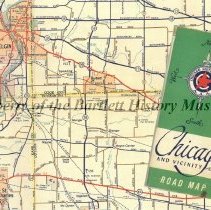
Description |
Map, 30" x 36" when open, 4" w x 9" l when folded. paper, full color, Front- green/white background, illustration of compass with directional words, in center red star encircled with a "C", in blue, "Chicago Motor Club, A.A.A." "Chicago and Vicinity Road Map", two sided, Road maps were once a must for any car journey. Do you still rely on them or have they been replaced by technology? The Chicago Motor Club, was once a local chapter of the American Automobile Association (A.A.A.) Today the chapter is known as The Auto Club Group. The A.A.A. was founded in Chicago in 1902. It published its first map in 1905. This 30" x 36" c. 1950 Chicago and Vicinity Road Map includes population figures (Bartlett 716), golf and country clubs (Bartlett Hills), lakes (Island Lake/Lost Island Lake), hospitals, parks, places of interest, forest preserves and picnic area and more. Note Bartlett was solely in Cook County at that time. Safe travels! |
Year Range from |
1950 |
Year Range to |
1955 |
Material |
Paper |
Width (in) |
30.000 |
Length (in) |
36.000 |
Number of images |
1 |
Search Terms |
A.A.A. American Automobile Association Army Trail Road Bartlett Chicago Elgin Road Chicago Motor Club Cook County DuPage County Elgin Granger Illinois Pet Cemetery Munger Naperville Road North Avenue Oak Avenue Ontarioville Population Route 19 Route 20 Route 59 South Elgin Spaulding Stearns Road Wayne Center Wayne Forest Preserves |
Subjects |
Cities & towns Forests Golf courses Highways Lakes & ponds Maps Picnic areas Roads |
Accession number |
A05-1 |