Search Term Record
Metadata
Name |
Ingalton Road |
Number of Archive records |
0 |
Number of Library records |
0 |
Number of Object records |
2 |
Number of Photo records |
0 |
Related Records
-
2025.37.1 - Plat
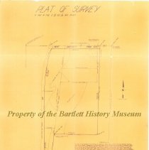
Plat, 23" w x 35" l, paper, Front- "Plat of Survey of Part of the E 1/2 S.E. 1/4 Sec. 33-41-9 , southeast corner of W. Bartlett Road and Route 59, three parcels, dated March 4, 1977 The last owners of this piece of farmland, located at the southeast corner of W. Bartlett Road and Rt. 59, was John and Hedwig Graf. On their property was their home, a barn and five sheds. In 1977 they sold their property to the Bergson Co. who developed the land ...
Record Type: Object
-
2025.37.2 - Map
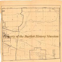
Map, 26" w x 29" l, paper, no date, Front- printed in black, along bottom- "Richard J. Daley, county clerk, Hanover Township, Cook County, Illinois, Scale: 4 inches - 1 mile", streets, highways, roads, cemeteries, schools, train stations, creeks, gravel pits, golf courses are illustrated on map, all of Bartlett and Ontarioville, part of Elgin is included. Dating between 1950-1955, this map illustrates Hanover Township. At that time Bartlett wa...
Record Type: Object