Search Term Record
Metadata
Name |
Gravel pits |
Number of Archive records |
0 |
Number of Library records |
0 |
Number of Object records |
2 |
Number of Photo records |
0 |
Related Records
-
2016.1.19 - Map
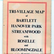
Map, 32" x 21" unfolded, 10 1/2" x 5" folded, paper, white, printed in black and red, "Tri-Village Map of Bartlett, Hanover Park, Streamwood with Roselle and Bloomingdale ..." two-sided, Side A- Bartlett, Hanover Park, Wayne, Streamwood, Schaumburg, Hoffman Estates, Elgin, Side B- Bloomingdale, Roselle, Medinah, Hanover Park, Schaumburg and Glendale Heights. Created in 1971, by Bartlett cartographer John Isard, the map illustrates the communit...
Record Type: Object
-
2025.37.2 - Map
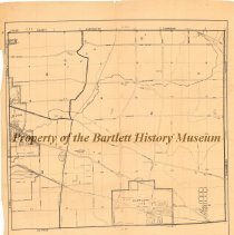
Map, 26" w x 29" l, paper, no date, Front- printed in black, along bottom- "Richard J. Daley, county clerk, Hanover Township, Cook County, Illinois, Scale: 4 inches - 1 mile", streets, highways, roads, cemeteries, schools, train stations, creeks, gravel pits, golf courses are illustrated on map, all of Bartlett and Ontarioville, part of Elgin is included. Dating between 1950-1955, this map illustrates Hanover Township. At that time Bartlett wa...
Record Type: Object