Search Term Record
Metadata
Name |
Gravel pit |
Number of Archive records |
1 |
Number of Library records |
1 |
Number of Object records |
1 |
Number of Photo records |
3 |
Related Records
-
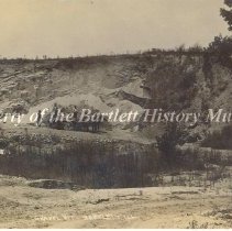
2018.15.2 - Print, photographic
Print, photographic, 8" x 10", sepia, rocky hill with brush, trees and 3 men with wagon pulled by two horses. Written in white at bottom, "Gravel Pit, Bartlett, ILL. Scratch the surface of Bartlett and you'll find land rich in limestone and gravel left behind by the Ice Age. The exact location of this gravel pit is unknown, though mining still exists today in the community.
Record Type: Photo
-
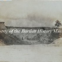
2021.1.82 - Print, Photographic
Print, photographic, 6 3/4"w x 4 3/4" l, sepia, Front- two men standing in the distance in a gravel pit, Back- removed from album, black paper remnants, written in ink upper right corner- "Gravel pit". The exact location of the gravel pit is unknown, through there were early gravel pits near where Spaulding Road is today. No other information is known about this photo whose donor is unknown. Local newspapers reported on area limestone grave...
Record Type: Photo
-
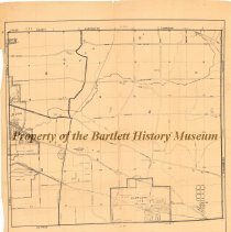
2025.37.2 - Map
Map, 26" w x 29" l, paper, no date, Front- printed in black, along bottom- "Richard J. Daley, county clerk, Hanover Township, Cook County, Illinois, Scale: 4 inches - 1 mile", streets, highways, roads, cemeteries, schools, train stations, creeks, gravel pits, golf courses are illustrated on map, all of Bartlett and Ontarioville, part of Elgin is included. Dating between 1950-1955, this map illustrates Hanover Township. At that time Bartlett wa...
Record Type: Object