Search Term Record
Metadata
Name |
Berteau Avenue |
Number of Archive records |
4 |
Number of Library records |
1 |
Number of Object records |
2 |
Number of Photo records |
0 |
Related Records
-
2016.20.18 - Map
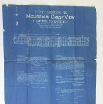
Map, plat, 24" x 21", paper, blueprint with white lettering, illustrates the location of the 80 lots and streets within the first addition to Crest View Subdivision, created by the Service Surveying and Engineering Company, whose seal is imprinted on the right side, back is plain. This plat was never recorded indicated by left portion of information not having dates or signatures, meaning this addition did not happen as this plat map indicate...
Record Type: Object
-
2025.37.2 - Map
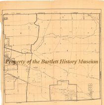
Map, 26" w x 29" l, paper, no date, Front- printed in black, along bottom- "Richard J. Daley, county clerk, Hanover Township, Cook County, Illinois, Scale: 4 inches - 1 mile", streets, highways, roads, cemeteries, schools, train stations, creeks, gravel pits, golf courses are illustrated on map, all of Bartlett and Ontarioville, part of Elgin is included. Dating between 1950-1955, this map illustrates Hanover Township. At that time Bartlett wa...
Record Type: Object